|
| at: |
Sumter National Forest - Long Cane District |
Data from USFS GIS
 show on map
 animate
Trail users:


Elevation Profile
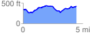
 4.484760 mi
 467.88 ft
 375.19 ft
 92.69 ft
 1.98 %
GPX Downloads: Track Route
![]()
|
| at: |
Sumter National Forest - Long Cane District |
show on map
animate
4.484760 mi
467.88 ft
375.19 ft
92.69 ft
1.98 %