| at: |
Sumter National Forest - Long Cane District |
Data from USFS GIS
 show on map
 animate
Trail users:


Elevation Profile
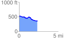
 2.355566 mi
 103.01 ft
 290.41 ft
 -187.40 ft
 2.33 %
GPX Downloads: Track Route
![]()
| at: |
Sumter National Forest - Long Cane District |
show on map
animate
2.355566 mi
103.01 ft
290.41 ft
-187.40 ft
2.33 %