|
| at: |
Cohutta Pinhoti Trans North Georgia Mulberry Gap |
Data from David Muse
 show on map
 animate
This road is marked FS90B in the field and on USGS maps, but FS90A on USGS GIS data.
Trail users:


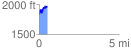
Elevation Profile
 0.509966 mi
 193.43 ft
 86.23 ft
 107.20 ft
 7.18 %
GPX Downloads: Track Route