|
| at: |
Conecuh National Forest |
Data from USFS GIS
 show on map
 animate
Trail users:


Elevation Profile
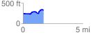
 1.717177 mi
 159.24 ft
 75.50 ft
 83.74 ft
 1.76 %
GPX Downloads: Track Route
![]()
|
| at: |
Conecuh National Forest |
show on map
animate
1.717177 mi
159.24 ft
75.50 ft
83.74 ft
1.76 %