|
| at: |
Conecuh National Forest |
Data from USFS GIS
 show on map
 animate
Trail users:


Elevation Profile
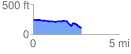
 2.855795 mi
 119.15 ft
 246.47 ft
 -127.32 ft
 1.63 %
GPX Downloads: Track Route
![]()
|
| at: |
Conecuh National Forest |
show on map
animate
2.855795 mi
119.15 ft
246.47 ft
-127.32 ft
1.63 %