|
| at: |
Conecuh National Forest |
Data from USFS GIS
 show on map
 animate
Trail users:


Elevation Profile
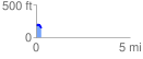
 0.273510 mi
 9.78 ft
 58.17 ft
 -48.39 ft
 4.03 %
GPX Downloads: Track Route
![]()
|
| at: |
Conecuh National Forest |
show on map
animate
0.273510 mi
9.78 ft
58.17 ft
-48.39 ft
4.03 %