|
| at: |
Conecuh National Forest |
Data from USFS GIS
 show on map
 animate
Trail users:


Elevation Profile
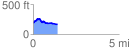
 1.424889 mi
 109.83 ft
 126.15 ft
 -16.31 ft
 1.68 %
GPX Downloads: Track Route
![]()
|
| at: |
Conecuh National Forest |
show on map
animate
1.424889 mi
109.83 ft
126.15 ft
-16.31 ft
1.68 %