|
| at: |
Conecuh National Forest |
Data from USFS GIS
 show on map
 animate
Trail users:


Elevation Profile
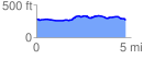
 4.750216 mi
 193.21 ft
 208.95 ft
 -15.75 ft
 0.83 %
GPX Downloads: Track Route
![]()
|
| at: |
Conecuh National Forest |
show on map
animate
4.750216 mi
193.21 ft
208.95 ft
-15.75 ft
0.83 %