| at: |
Conecuh National Forest |
Data from USFS GIS
 show on map
 animate
Trail users:


Elevation Profile
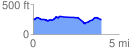
 4.032513 mi
 243.43 ft
 256.74 ft
 -13.32 ft
 1.21 %
GPX Downloads: Track Route
![]()
| at: |
Conecuh National Forest |
show on map
animate
4.032513 mi
243.43 ft
256.74 ft
-13.32 ft
1.21 %