| at: |
Conecuh National Forest |
Data from USFS GIS
 show on map
 animate
Trail users:


Elevation Profile
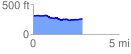
 2.895929 mi
 82.69 ft
 136.17 ft
 -53.49 ft
 0.89 %
GPX Downloads: Track Route
![]()
| at: |
Conecuh National Forest |
show on map
animate
2.895929 mi
82.69 ft
136.17 ft
-53.49 ft
0.89 %