|
| at: |
Conecuh National Forest |
Data from USFS GIS
 show on map
 animate
Trail users:


Elevation Profile
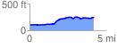
 4.284928 mi
 260.97 ft
 92.66 ft
 168.31 ft
 1.15 %
GPX Downloads: Track Route
![]()
|
| at: |
Conecuh National Forest |
show on map
animate
4.284928 mi
260.97 ft
92.66 ft
168.31 ft
1.15 %