|
| at: |
Conecuh National Forest |
Data from USFS GIS
 show on map
 animate
Trail users:


Elevation Profile
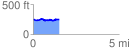
 1.520030 mi
 78.82 ft
 81.11 ft
 -2.29 ft
 1.01 %
GPX Downloads: Track Route
![]()
|
| at: |
Conecuh National Forest |
show on map
animate
1.520030 mi
78.82 ft
81.11 ft
-2.29 ft
1.01 %