|
| at: |
Conecuh National Forest |
Data from USFS GIS
 show on map
 animate
Trail users:


Elevation Profile
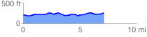
 7.169997 mi
 354.57 ft
 300.04 ft
 54.53 ft
 0.94 %
GPX Downloads: Track Route
![]()
|
| at: |
Conecuh National Forest |
show on map
animate
7.169997 mi
354.57 ft
300.04 ft
54.53 ft
0.94 %