|
| at: |
Conecuh National Forest |
Data from USFS GIS
 show on map
 animate
Trail users:


Elevation Profile
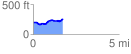
 1.726189 mi
 138.27 ft
 75.21 ft
 63.06 ft
 1.52 %
GPX Downloads: Track Route
![]()
|
| at: |
Conecuh National Forest |
show on map
animate
1.726189 mi
138.27 ft
75.21 ft
63.06 ft
1.52 %