|
| at: |
Conecuh National Forest |
Data from USFS GIS
 show on map
 animate
Trail users:


Elevation Profile
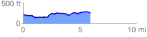
 6.001046 mi
 291.48 ft
 240.24 ft
 51.24 ft
 0.92 %
GPX Downloads: Track Route
![]()
|
| at: |
Conecuh National Forest |
show on map
animate
6.001046 mi
291.48 ft
240.24 ft
51.24 ft
0.92 %