|
| at: |
Bankhead National Forest |
Data from USFS GIS
 show on map
 animate
Trail users:


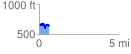
Elevation Profile
 0.644039 mi
 113.27 ft
 153.22 ft
 -39.95 ft
 4.51 %
GPX Downloads: Track Route
![]()
|
| at: |
Bankhead National Forest |
show on map
animate
0.644039 mi
113.27 ft
153.22 ft
-39.95 ft
4.51 %