|
| at: |
Talladega National Forest |
Data from USFS GIS
 show on map
 animate
Trail users:


Elevation Profile
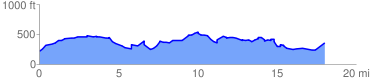
 18.538431 mi
 1752.59 ft
 1588.09 ft
 164.50 ft
 1.79 %
GPX Downloads: Track Route
![]()
|
| at: |
Talladega National Forest |
show on map
animate
18.538431 mi
1752.59 ft
1588.09 ft
164.50 ft
1.79 %