| at: |
Talladega National Forest |
Data from USFS GIS
 show on map
 animate
Trail users:


Elevation Profile
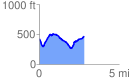
 2.876629 mi
 452.75 ft
 446.33 ft
 6.42 ft
 2.98 %
GPX Downloads: Track Route
![]()
| at: |
Talladega National Forest |
show on map
animate
2.876629 mi
452.75 ft
446.33 ft
6.42 ft
2.98 %