|
| at: |
Talladega National Forest |
Data from USFS GIS
 show on map
 animate
Trail users:


Elevation Profile
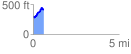
 0.607944 mi
 172.95 ft
 72.95 ft
 100.00 ft
 5.39 %
GPX Downloads: Track Route
![]()
|
| at: |
Talladega National Forest |
show on map
animate
0.607944 mi
172.95 ft
72.95 ft
100.00 ft
5.39 %