| at: |
Iron Legs |
Data from David Muse
 show on map
 animate
Trail users:


Elevation Profile
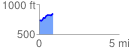
 0.859851 mi
 144.36 ft
 32.32 ft
 112.05 ft
 3.18 %
GPX Downloads: Track Route
Trailheads:
 Iron Legs
![]()
| at: |
Iron Legs |
show on map
animate
0.859851 mi
144.36 ft
32.32 ft
112.05 ft
3.18 %
Iron Legs