| at: |
Tombigbee National Forest - South |
Data from USFS GIS
 show on map
 animate
Trail users:


Elevation Profile
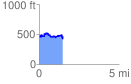
 1.510513 mi
 311.30 ft
 288.87 ft
 22.43 ft
 3.90 %
GPX Downloads: Track Route
![]()
| at: |
Tombigbee National Forest - South |
show on map
animate
1.510513 mi
311.30 ft
288.87 ft
22.43 ft
3.90 %