| at: |
Tombigbee National Forest - South |
Data from USFS GIS
 show on map
 animate
Trail users:


Elevation Profile
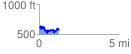
 1.249889 mi
 285.82 ft
 312.95 ft
 -27.13 ft
 4.74 %
GPX Downloads: Track Route
![]()
| at: |
Tombigbee National Forest - South |
show on map
animate
1.249889 mi
285.82 ft
312.95 ft
-27.13 ft
4.74 %