|
| at: |
Tombigbee National Forest - South |
Data from USFS GIS
 show on map
 animate
Trail users:


Elevation Profile
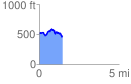
 1.458259 mi
 239.69 ft
 275.53 ft
 -35.84 ft
 3.58 %
GPX Downloads: Track Route
![]()
|
| at: |
Tombigbee National Forest - South |
show on map
animate
1.458259 mi
239.69 ft
275.53 ft
-35.84 ft
3.58 %