|
| at: |
Holly Springs National Forest - North |
Data from USFS GIS
 show on map
 animate
Trail users:


Elevation Profile
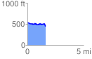
 1.605181 mi
 107.50 ft
 186.84 ft
 -79.34 ft
 2.20 %
GPX Downloads: Track Route
![]()
|
| at: |
Holly Springs National Forest - North |
show on map
animate
1.605181 mi
107.50 ft
186.84 ft
-79.34 ft
2.20 %