|
| at: |
Bienville National Forest |
Data from USFS GIS
 show on map
 animate
Trail users:


Elevation Profile
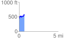
 0.673832 mi
 213.92 ft
 93.55 ft
 120.36 ft
 6.01 %
GPX Downloads: Track Route
![]()
|
| at: |
Bienville National Forest |
show on map
animate
0.673832 mi
213.92 ft
93.55 ft
120.36 ft
6.01 %