| at: |
Bienville National Forest |
Data from USFS GIS
 show on map
 animate
Trail users:


Elevation Profile
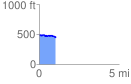
 1.047016 mi
 73.90 ft
 129.66 ft
 -55.77 ft
 2.35 %
GPX Downloads: Track Route
![]()
| at: |
Bienville National Forest |
show on map
animate
1.047016 mi
73.90 ft
129.66 ft
-55.77 ft
2.35 %