| at: |
Bienville National Forest |
Data from USFS GIS
 show on map
 animate
Trail users:


Elevation Profile
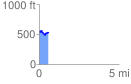
 0.577796 mi
 53.96 ft
 85.48 ft
 -31.51 ft
 2.80 %
GPX Downloads: Track Route
![]()
| at: |
Bienville National Forest |
show on map
animate
0.577796 mi
53.96 ft
85.48 ft
-31.51 ft
2.80 %