| at: |
Bienville National Forest |
Data from USFS GIS
 show on map
 animate
Trail users:


Elevation Profile
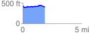
 1.860730 mi
 130.88 ft
 163.61 ft
 -32.73 ft
 1.67 %
GPX Downloads: Track Route
![]()
| at: |
Bienville National Forest |
show on map
animate
1.860730 mi
130.88 ft
163.61 ft
-32.73 ft
1.67 %