|
| at: |
Bienville National Forest |
Data from USFS GIS
 show on map
 animate
Trail users:


Elevation Profile
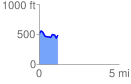
 1.174974 mi
 137.85 ft
 173.85 ft
 -36.00 ft
 2.80 %
GPX Downloads: Track Route
![]()
|
| at: |
Bienville National Forest |
show on map
animate
1.174974 mi
137.85 ft
173.85 ft
-36.00 ft
2.80 %