| at: |
Bienville National Forest |
Data from USFS GIS
 show on map
 animate
Trail users:


Elevation Profile
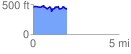
 1.973888 mi
 222.87 ft
 224.72 ft
 -1.86 ft
 2.16 %
GPX Downloads: Track Route
![]()
| at: |
Bienville National Forest |
show on map
animate
1.973888 mi
222.87 ft
224.72 ft
-1.86 ft
2.16 %