|
| at: |
Bienville National Forest |
Data from USFS GIS
 show on map
 animate
Trail users:


Elevation Profile
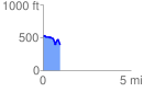
 0.974866 mi
 115.34 ft
 232.64 ft
 -117.30 ft
 4.52 %
GPX Downloads: Track Route
![]()
|
| at: |
Bienville National Forest |
show on map
animate
0.974866 mi
115.34 ft
232.64 ft
-117.30 ft
4.52 %