|
| at: |
Bienville National Forest |
Data from USFS GIS
 show on map
 animate
Trail users:


Elevation Profile
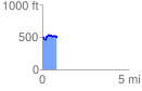
 0.825270 mi
 116.38 ft
 102.33 ft
 14.04 ft
 2.67 %
GPX Downloads: Track Route
![]()
|
| at: |
Bienville National Forest |
show on map
animate
0.825270 mi
116.38 ft
102.33 ft
14.04 ft
2.67 %