| at: |
Bienville National Forest |
Data from USFS GIS
 show on map
 animate
Trail users:


Elevation Profile
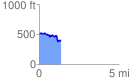
 1.358151 mi
 113.44 ft
 228.26 ft
 -114.81 ft
 3.18 %
GPX Downloads: Track Route
![]()
| at: |
Bienville National Forest |
show on map
animate
1.358151 mi
113.44 ft
228.26 ft
-114.81 ft
3.18 %