|
| at: |
Bienville National Forest |
Data from USFS GIS
 show on map
 animate
Trail users:


Elevation Profile
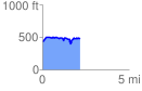
 2.169405 mi
 271.30 ft
 210.11 ft
 61.18 ft
 2.37 %
GPX Downloads: Track Route
![]()
|
| at: |
Bienville National Forest |
show on map
animate
2.169405 mi
271.30 ft
210.11 ft
61.18 ft
2.37 %