|
| at: |
Bienville National Forest |
Data from USFS GIS
 show on map
 animate
Trail users:


Elevation Profile
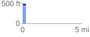
 0.257889 mi
 20.91 ft
 37.31 ft
 -16.40 ft
 2.74 %
GPX Downloads: Track Route
![]()
|
| at: |
Bienville National Forest |
show on map
animate
0.257889 mi
20.91 ft
37.31 ft
-16.40 ft
2.74 %