|
| at: |
Bienville National Forest |
Data from USFS GIS
 show on map
 animate
Trail users:


Elevation Profile
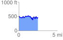
 2.458679 mi
 419.62 ft
 464.13 ft
 -44.51 ft
 3.58 %
GPX Downloads: Track Route
![]()
|
| at: |
Bienville National Forest |
show on map
animate
2.458679 mi
419.62 ft
464.13 ft
-44.51 ft
3.58 %