| at: |
Bienville National Forest |
Data from USFS GIS
 show on map
 animate
Trail users:


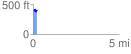
Elevation Profile
 0.214075 mi
 46.17 ft
 36.40 ft
 9.77 ft
 4.08 %
GPX Downloads: Track Route
![]()
| at: |
Bienville National Forest |
show on map
animate
0.214075 mi
46.17 ft
36.40 ft
9.77 ft
4.08 %