|
| at: |
Bienville National Forest |
Data from USFS GIS
 show on map
 animate
Trail users:


Elevation Profile
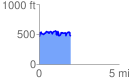
 1.961359 mi
 399.04 ft
 472.42 ft
 -73.38 ft
 4.56 %
GPX Downloads: Track Route
![]()
|
| at: |
Bienville National Forest |
show on map
animate
1.961359 mi
399.04 ft
472.42 ft
-73.38 ft
4.56 %