| at: |
Bienville National Forest |
Data from USFS GIS
 show on map
 animate
Trail users:


Elevation Profile
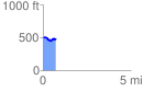
 0.727878 mi
 86.69 ft
 108.62 ft
 -21.93 ft
 2.83 %
GPX Downloads: Track Route
![]()
| at: |
Bienville National Forest |
show on map
animate
0.727878 mi
86.69 ft
108.62 ft
-21.93 ft
2.83 %