| at: |
Bienville National Forest |
Data from USFS GIS
 show on map
 animate
Trail users:


Elevation Profile
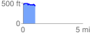
 1.025881 mi
 93.91 ft
 137.82 ft
 -43.91 ft
 2.54 %
GPX Downloads: Track Route
![]()
| at: |
Bienville National Forest |
show on map
animate
1.025881 mi
93.91 ft
137.82 ft
-43.91 ft
2.54 %