|
| at: |
Bienville National Forest |
Data from USFS GIS
 show on map
 animate
Trail users:


Elevation Profile
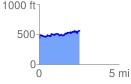
 2.551723 mi
 359.62 ft
 232.57 ft
 127.05 ft
 2.67 %
GPX Downloads: Track Route
![]()
|
| at: |
Bienville National Forest |
show on map
animate
2.551723 mi
359.62 ft
232.57 ft
127.05 ft
2.67 %