| at: |
Bienville National Forest |
Data from USFS GIS
 show on map
 animate
Trail users:


Elevation Profile
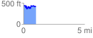
 1.036652 mi
 227.53 ft
 243.60 ft
 -16.07 ft
 4.45 %
GPX Downloads: Track Route
![]()
| at: |
Bienville National Forest |
show on map
animate
1.036652 mi
227.53 ft
243.60 ft
-16.07 ft
4.45 %