|
| at: |
Bienville National Forest |
Data from USFS GIS
 show on map
 animate
Trail users:


Elevation Profile
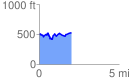
 2.010631 mi
 282.29 ft
 248.06 ft
 34.23 ft
 2.66 %
GPX Downloads: Track Route
![]()
|
| at: |
Bienville National Forest |
show on map
animate
2.010631 mi
282.29 ft
248.06 ft
34.23 ft
2.66 %