| at: |
Bienville National Forest |
Data from USFS GIS
 show on map
 animate
Trail users:


Elevation Profile
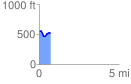
 0.707851 mi
 76.09 ft
 100.72 ft
 -24.63 ft
 2.69 %
GPX Downloads: Track Route
![]()
| at: |
Bienville National Forest |
show on map
animate
0.707851 mi
76.09 ft
100.72 ft
-24.63 ft
2.69 %