| at: |
Bienville National Forest |
Data from USFS GIS
 show on map
 animate
Trail users:


Elevation Profile
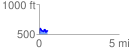
 0.548189 mi
 140.91 ft
 107.17 ft
 33.75 ft
 4.87 %
GPX Downloads: Track Route
![]()
| at: |
Bienville National Forest |
show on map
animate
0.548189 mi
140.91 ft
107.17 ft
33.75 ft
4.87 %