|
| at: |
Bienville National Forest |
Data from USFS GIS
 show on map
 animate
Trail users:


Elevation Profile
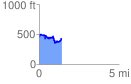
 1.405342 mi
 281.79 ft
 299.97 ft
 -18.18 ft
 4.04 %
GPX Downloads: Track Route
![]()
|
| at: |
Bienville National Forest |
show on map
animate
1.405342 mi
281.79 ft
299.97 ft
-18.18 ft
4.04 %