|
| at: |
Bienville National Forest |
Data from USFS GIS
 show on map
 animate
Trail users:


Elevation Profile
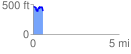
 0.557909 mi
 108.33 ft
 168.23 ft
 -59.90 ft
 5.71 %
GPX Downloads: Track Route
![]()
|
| at: |
Bienville National Forest |
show on map
animate
0.557909 mi
108.33 ft
168.23 ft
-59.90 ft
5.71 %