|
| at: |
Bienville National Forest |
Data from USFS GIS
 show on map
 animate
Trail users:


Elevation Profile
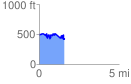
 1.578630 mi
 348.59 ft
 380.24 ft
 -31.65 ft
 4.56 %
GPX Downloads: Track Route
![]()
|
| at: |
Bienville National Forest |
show on map
animate
1.578630 mi
348.59 ft
380.24 ft
-31.65 ft
4.56 %