|
| at: |
Bienville National Forest |
Data from USFS GIS
 show on map
 animate
Trail users:


Elevation Profile
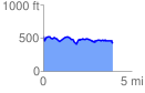
 3.905340 mi
 326.73 ft
 436.73 ft
 -110.00 ft
 2.12 %
GPX Downloads: Track Route
![]()
|
| at: |
Bienville National Forest |
show on map
animate
3.905340 mi
326.73 ft
436.73 ft
-110.00 ft
2.12 %