| at: |
Kisatchie National Forest - Caney District |
Data from USFS GIS
 show on map
 animate
Trail users:


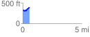
Elevation Profile
 0.586502 mi
 108.28 ft
 65.40 ft
 42.89 ft
 3.50 %
GPX Downloads: Track Route
![]()
| at: |
Kisatchie National Forest - Caney District |
show on map
animate
0.586502 mi
108.28 ft
65.40 ft
42.89 ft
3.50 %